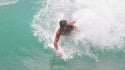
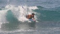
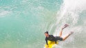
Quantcast
SwellInfo.com
     LOGIN | REGISTER
SwellInfo.com
Title Bar Seperator Title Bar Seperator Title Bar Seperator Title Bar Seperator Title Bar Seperator Title Bar Seperator Title Bar Seperator
SwellInfo.com Navigation
Spacer

KENNEBUNK, ME

clear 44 ° Ocean Temperature 49° Wind WSW @ 6 kts
buoy data Buoy 44030
3.6ft @ 6sec
tide data 
Low: 7:42 PM
High: 1:11 PM

leftcrv spacer

DETAILED SURF FORECAST

  change
spacer
help
rtcrv
BEACH FACING DIRECTION 
ESENES
Swell Info Surf Reports Spacer
Bookmark and Share ICON LEGEND
  AM PM
Saturday rss feed    
Surf: Knee high SE wind swell.
Conditions: Clean with W winds 10-15kt in the morning shifting WNW for the afternoon.
Swell Info Surf Reports Spacer
Sunday    
Surf: Knee to thigh high SE wind swell.
Conditions: Sideshore/choppy with NNE winds 10-15kt in the morning shifting NE 5-10kt in the afternoon.
Swell Info Surf Reports Spacer
Monday    
Surf: Knee high E short period wind swell for the morning. The swell shifts more ESE and builds for the afternoon with sets up to stomach high.
Conditions: Choppy/disorganized with NE winds 10-15kt in the morning shifting ENE 5-10kt in the afternoon.
Swell Info Surf Reports Spacer
Tuesday    
Surf: Head high SE wind swell with occasional 1-2' overhead high sets.
Conditions: Choppy with SSE winds 15-20kt in the morning shifting SSW 5-10kt in the afternoon.
Swell Info Surf Reports Spacer
Wednesday    
Surf: Chest to shoulder high SE wind swell for the morning. This fades into the waist to chest range for the afternoon with occasional shoulder high sets.
Conditions: Sideshore/choppy with SSW winds 10-15kt in the morning shifting SW for the afternoon.
Swell Info Surf Reports Spacer
Thursday    
Surf: Waist to stomach high ESE wind swell with occasional chest high sets.
Conditions: Glassy in the morning with NNW winds less than 5kt. Semi glassy/semi bumpy conditions for the afternoon with the winds shifting to the SSE.
Swell Info Surf Reports Spacer
**Surf Height Definition**
Forecasted surf heights represent a potential wave face height for the average to better breaks in a region during optimal conditions (tides,wind,swell).
Swell Info Surf Reports Spacer
Forecast updated: Nov 20, 2009 5:11 PM EST

SWELL TABLE WEATHER FORECAST TIDE CHART WIND TABLE


spacer
leftcrv spacer

SURF REPORTS

spacer rtcrv
LocationWv Ht Cond'sPosted
2nd Beach, RInonenone8:47pm
Gilgo Beach, NYcamphoto surf report7:30am
Gilgo Beach, NYcamphoto surf report11/19
Westhampton Bea, NYnonephoto surf report11/18
Long Beach, NY
8-10+ ft11/15
Central LI, NY4-5 ftphoto surf report11/15
Gilgo Beach, NY
3 ft10/31
click or mouse over location for details | more surf reports

spacer
leftcrv spacer

NORTH EAST FORUM

spacer
POST    
rtcrv
Latest Entries User Post
Need 6'2 gun for Califisurf11/19
bunger surf report/cam ...kman11/19
haleiwa LIVE!kman11/19
FS: Canon Rebel XTiisurf11/19
FS: 6/5/4 Rip-Curl F-Bo...rgnsup11/19
LI tomorrowTheegreener11/18
long island..?Theegreener11/18

SURF PHOTOS

UPLOAD
November Nor'easter 
Mini Rails 
Thank You Ida 
Bodyboarding 
November Nor'easterMini RailsThank You IdaBodyboarding

SURF VIDEOS

SUBMIT
Ida New YorkShades of Indonesia TrailerPuddles In The Sky Surf MovieBalaram Stack, Shack

NEWS

ADD
Swellinfo Pre-Holiday Sale
BIG Ida, looking to clean up for the Northeast
Hurricane Ida enters the Gulf

leftcrv spacer

ATLANTIC TROPICAL SYSTEMS

OUTLOOK SATELLITE DISCUSSION rtcrv
There are currently no active systems for this region.


Copyright 2006-2009 Swellinfo. Use of this site is subject to the following Terms and Conditions and Privacy Policy.