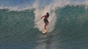
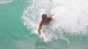
LOGIN | REGISTER

SOUTHEAST HAWAII, HI

Surf Forecast

AM
PM
Thursday
2-4 ft 2-4 ft

Surf

Waist to chest high mix of ESE short period wind swell and S ground swell.

Conditions

Light sideshore texture in the morning with NE winds 10-15mph. Choppy/disorganized conditions for the afternoon with the winds shifting to the ENE.

Wind Swell
6am NE 10mph ESE 4.3 ft @ 7 sec
9am NE 11mph ESE 4.6 ft @ 7 sec
12pm NE 12mph ESE 4.6 ft @ 7 sec
3pm ENE 13mph ESE 4.6 ft @ 7 sec
6pm ENE 13mph ESE 4.6 ft @ 7 sec
Friday
3-4+ ft 3-4+ ft

Surf

Waist to chest high E wind swell with occasional shoulder high sets.

Conditions

Choppy/disorganized with ENE winds 10-15mph.

TIDES
Low:6:48 AM -0.21 ft8:05 PM 0.65 ft
High:12:23 AM 2.27 ft1:51 PM 2.27 ft
Wind Swell
6am ENE 12mph ESE 4.9 ft @ 8 sec
9am ENE 12mph ESE 4.9 ft @ 8 sec
12pm ENE 13mph ESE 4.9 ft @ 8 sec
3pm ENE 13mph E 4.3 ft @ 7 sec
6pm ENE 13mph E 4.3 ft @ 7 sec
Saturday
3-4+ ft 3-4+ ft

Surf

Stomach to shoulder high ESE medium period swell for the morning mixes in with a similar size E ground swell during the afternoon.

Conditions

Semi choppy with ENE winds 10-15mph.

TIDES
Low:7:16 AM -0.30 ft8:45 PM 0.59 ft
High:12:58 AM 2.42 ft2:23 PM 2.42 ft
Wind Swell
6am ENE 10mph ESE 4.6 ft @ 8 sec
9am ENE 11mph ESE 4.6 ft @ 9 sec
12pm ENE 12mph ESE 4.6 ft @ 9 sec
3pm ENE 12mph E 3.6 ft @ 8 sec
6pm ENE 13mph E 3.3 ft @ 8 sec
Sunday
3+ ft 3+ ft

Surf

Waist to stomach high mix of E wind swell and SE medium period swell.

Conditions

Sideshore texture/chop with NE winds 5-10mph in the morning shifting ENE 10-15mph in the afternoon.

TIDES
Low:7:46 AM -0.36 ft9:23 PM 0.55 ft
High:1:31 AM 2.52 ft2:55 PM 2.52 ft
Wind Swell
6am NE 10mph E 3.3 ft @ 8 sec
9am ENE 10mph E 3.3 ft @ 8 sec
12pm ENE 12mph E 3.3 ft @ 8 sec
3pm ENE 13mph E 3.3 ft @ 8 sec
6pm ENE 13mph E 3.3 ft @ 8 sec
Monday
3 ft 1-3 ft

Surf

Waist high mix of E short period wind swell and SE medium period swell.

Conditions

Sideshore texture/chop with NE winds 5-10mph in the morning shifting ENE 10-15mph in the afternoon.

TIDES
Low:8:15 AM -0.39 ft10:00 PM 0.53 ft
High:2:05 AM 2.58 ft3:28 PM 2.58 ft
Wind Swell
6am NE 10mph E 3.0 ft @ 7 sec
9am ENE 10mph E 3.0 ft @ 7 sec
12pm ENE 11mph E 3.3 ft @ 7 sec
3pm ENE 12mph E 3.3 ft @ 6 sec
6pm ENE 12mph SE 2.0 ft @ 9 sec
Tuesday
2-4 ft 2-4 ft

Surf

Waist to chest high E short period wind swell.

Conditions

Semi choppy with ENE winds 5-10mph in the morning shifting E 10-15mph in the afternoon.

TIDES
Low:8:47 AM -0.39 ft10:39 PM 0.53 ft
High:2:39 AM 2.59 ft4:02 PM 2.59 ft
Wind Swell
6am ENE 7mph E 4.3 ft @ 7 sec
9am ENE 7mph E 4.9 ft @ 7 sec
12pm E 10mph E 4.9 ft @ 7 sec
3pm E 11mph E 5.2 ft @ 7 sec
6pm ENE 10mph E 5.2 ft @ 7 sec
Wednesday
N/A N/A

Surf

Conditions

Sideshore texture/chop with NE winds 5-10mph in the morning shifting ENE 10-15mph in the afternoon.

TIDES
Low:9:19 AM -0.35 ft11:19 PM 0.54 ft
High:3:13 AM 2.56 ft4:37 PM 2.56 ft
Wind Swell
6am mph ft @ sec
9am mph ft @ sec
12pm ESE 3mph S 2.3 ft @ 16 sec
3pm E 10mph S 2.3 ft @ 16 sec
6pm ENE 12mph ESE 3.6 ft @ 8 sec
  Kailua-Kona, HI 1-2 ft (03/13)
  Kailua-Kona, HI 4-5 ft (02/14)
  Kailua-Kona, HI 4-6 ft photo surf report (02/01)
  Kailua-Kona, HI 4-6 ft (02/01)
  Kailua-Kona, HI 4-5 ft (01/12)
  Kailua-Kona, HI 2-3 ft photo surf report (01/07)
  Kailua-Kona, HI 2-4 ft photo surf report (01/04)
  Kailua-Kona, HI 2+ ft (12/31)
  Kailua-Kona, HI 1-2 ft (12/29)
  Kailua-Kona, HI 0-1 ft photo surf report (12/28)
78° Ocean Temperature 76° Wind  Wind - PHKO
 SSW @ 4 kts
Buoy Data  Buoy 51202
 5.6ft @ 10sec
tides  Low: 7:21 PM
 High: 1:18 PM

Surf and Swell Timeline (requires flash)

Get Adobe Flash player

SWELL TABLE WEATHER FORECAST TIDE CHART WIND TABLE

Swellinfo Maps

(flash required)

Get Adobe Flash player